
In the first five months of 2024, 5,3 million hectares were damaged by wildfires in Russia.

The top ten regions where the fire swept the largest areas included the Jewish Autonomous Region, Astrakhan Region, Zabaykalsky Krai, Amur Region, Primorsky and Khabarovsk Krai, Karachay-Cherkessia, Buryatia, Voronezh and Kursk Regions.
These figures are published by "The earth touches everyone"The project conducted its research using artificial intelligence. This method, the project's experts say, was dictated by necessity: currently, the country lacks official sources that provide information not only on forest fires, but on all types of landscape fires on lands of all categories.
Where do these numbers come from?
Until recently, large-scale landscape fires—particularly those burning dry grass—were generally considered, by order of the Ministry of Emergency Situations, "fires not subject to official statistical recording." In 2019, the system was formally changed, and all types of landscape fires were now supposed to be counted, but in reality, a fully functional system has yet to be created.

As a result, data on forest fires exists, and from various sources—from field reports and the ISDM-Rosleskhoz remote monitoring system—but for other types of forest fires, there is simply no information: even the indicators by which they should be recorded have not been defined. Therefore, the data is obtained through analysis. Eastern European landscape fire maps, which is created using artificial intelligence, as of May 31, 2024 inclusive.
Therefore, says Alexey Yaroshenko, an expert with the “Earth Touches Everyone” project, to be precise, from January 1 to May 31 inclusive, the total area of landscape fires amounted to about 5,3 million hectares: "Why approximately? Firstly, because the map is currently in test mode, being verified and refined. Secondly, a small portion of the fires are still considered unconfirmed; they will be verified as new cloud-free satellite images of the relevant areas become available, but they are not yet included in the final figure. Nevertheless, this is fairly accurate data for judging the overall scale of landscape fires and where and what burned most intensely."
What was burning?
Of the spring landscape fires, 18% occurred in forests, and 82% in various open, treeless spaces. This is generally typical of the spring peak of landscape fires in Russia: fires spread most quickly through dry, last year's grass, reeds, or stubble, engulfing vast treeless areas, and from there spreading to forests, peatlands, settlements, and infrastructure.

"The most important conclusion from this is very simple," says Alexey Yaroshenko: "If we don't defeat fires in treeless areas (and these are mainly unused or underused agricultural lands), then we won't be able to cope with fires in other natural areas, including forests and peatlands."
It's worth noting that young forests are growing not only on forest-regulated lands but also on abandoned agricultural lands, which account for approximately 10% of all Russian forests. These lands are considered agricultural in name only; they are not used for their intended purpose because they are not needed for agriculture, and there is no one to cultivate them. In many areas, the only chance of returning these lands to some kind of sustainable management is to develop forestry. But this is currently prohibited under threat of huge fines and land seizure. Therefore, these forests are not extinguished; they are often deliberately destroyed—simply burned—and a large proportion of spring fires occur there.
Where and how much burned?
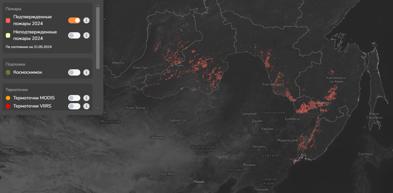
The largest contribution to the total area of spring landscape fires in 2024 (89%) was made by six regions of the Far Eastern Federal District: the Jewish Autonomous Region (30,4% of the region’s area), Amur Region (2,4%), Zabaykalsky Krai (2,4%), Primorsky Krai (2,3%), Khabarovsk Krai (1,2%), and the Republic of Buryatia (0,9%).
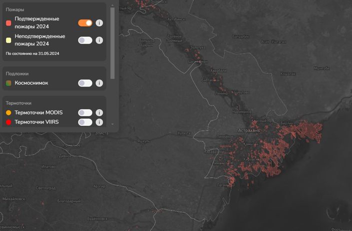
In the European part of the country, the Astrakhan region suffered the most from wildfires.
Why there?
In the Far East, so-called preventative burning has been actively carried out over vast areas for many years. It's believed that burning dry grass near forests beforehand will reduce the risk of fires. In reality, regular burning makes the area increasingly fire-prone. There's also a peculiar advertising effect. When government and municipal employees, often in the form of forestry or fire departments, burn grass themselves, it's virtually impossible to convince other citizens not to do so. As a result, everything burns from horizon to horizon.

The situation is different in the lower Volga region of the Astrakhan region. There's a special exception: burning rice straw is permitted, unlike any other kind. "The arsonist frenzy in the lower Volga region largely begins with the burning of rice fields and checks," says Yaroshenko. "These fields are used to maintain the required water level during the rice-growing season. There are also very unique local fire-hazardous practices—for example, burning areas where fishermen plan to set their nets during the flood season (to keep the reeds out of the way), or setting fires to distract nature reserve inspectors or fisheries officials from poachers. And this is true everywhere where fire is widely used in agriculture."
Is it worse this year than before?
To assess whether this is a larger or smaller number of fires than in previous years, experts compared the number of hotspots—points on the map where elevated temperatures are observed. (They're red on this map.) These hotspots are obtained using the Terra and Aqua satellites, both veterans and operational for about a quarter of a century. The vast majority of these hotspots are associated with landscape fires, so their total number is roughly proportional to the scale of these fires.
A comparison of the number of hotspots shows that there have been fewer fires this year than the average since the beginning of the century. Of course, in specific regions there were catastrophic fires and related emergencies, burned-out houses in villages and towns, and even fatalities from wildfires, but nationally, the situation with spring wildfires has been much calmer than in previous years.
"Why did this happen?" asks Alexey Yaroshenko. "Clearly, some luck was involved: in most large regions, the spring was relatively cool and damp, and some regions actually sank rather than burned. But it wasn't just luck; some very sensible decisions also led to an improvement in the situation. For example, the ban on unauthorized burning of dry grass, the general reduction in spring preventative fires on forest lands, and the change in the firefighting services' attitude toward peat fires, including wintering ones (previously, they were largely ignored in the early stages; now they are actually trying to suppress them)."

Nevertheless, there were numerous fires in late spring. June typically marks a break between the spring and summer peaks, but a state of emergency is already in effect in the Zabaikalsky Krai, Buryatia, some areas of Yakutia, Khabarovsk Krai, and Amur Oblast. Experts note that forest fires have already reached the northern boundary of the forest zone and even entered the tundra—the northernmost fire is burning in Yakutia, approximately 300 kilometers north of the Arctic Circle. Five fires in Yakutia and another five in Amur Oblast are burning in so-called control zones—remote and inaccessible forests where, by law, fires are allowed to remain unextinguished, and they are not being extinguished.
The material was prepared jointly with the project "The earth touches everyone»
Photos provided by the project «The earth touches everyone»